Publications
1-8 of 8
-
-
Road Safety Data
Improving Road Traffic Injury Statistics in Low- and Middle-Income Countries
November 2023
- National decision-makers recognize the issue of underreporting but tend to dismiss higher estimates by global statistical models.
- Most countries use WHO GSRRS estimates.
- National health surveys and censuses in LMICs often contain relevant information, and minor modifications can greatly improve their usage for such measurements.
- Incorporating national health survey data into global statistical models can help resolve discrepancies and increase confidence in estimates.
- Integrating epidemiological data sources into global statistical models (GBD, GHE, GSRRS) to reduce discrepancies and increase confidence in their estimates.
- Including relevant questions in upcoming national data collections to facilitate epidemiological measurements of road traffic injuries.
- Encouraging local involvement in data production for better estimates.
- Enhancing coordination between the Institute for Health Metrics and Evaluation and the World Health Organization to improve estimates and reduce inconsistencies.
-

-
-

-
-

-
Road Safety Data
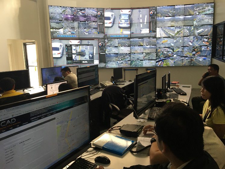
DRIVER: The World Bank’s Sustainable Solution for Road Crash Data Management
March 2018

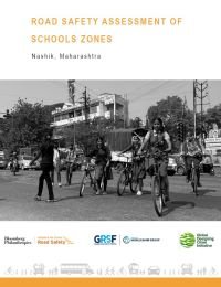
This report spotlights dangerous conditions around school zones in Nashik, Maharashtra, and offers a practical roadmap to protect children during their daily commutes. Developed in partnership with the Nashik Municipal Corporation under the Bloomberg Initiative for Global Road Safety (BIGRS), the report focuses on two schools—Adarsh English Medium School and NMC School 57—where students face serious risks due to poor road infrastructure.
Surveys revealed that while 86% of students at NMC School 57 walk to school, many cite unsafe roads, speeding vehicles, and a lack of footpaths, crossings, and lighting as major concerns. The report recommends a range of interventions: better pedestrian and cycling infrastructure, traffic calming measures, improved signage, and reduced speed limits near schools.
It also calls for establishing School Zone Road Safety Committees to coordinate action and promote awareness. By prioritizing the safety of young pedestrians, this report provides a replicable model for safer school zones in fast-growing cities across India.

Road safety is a global health and economic issue that disproportionately affects low- and middle-income countries (LMICs). Precise data is crucial for understanding the full scope of the problem and developing effective interventions, but LMICs struggle to collect comprehensive data due to limited resources, underdeveloped health systems, and inconsistent data collection processes.
To overcome reporting gaps, three major global statistical models are utilized: The Institute for Health Metrics and Evaluation Global Burden of Disease (GBD) study, the World Health Organization (WHO) Global Status Reports on Road Safety (GSRRS), and WHO Global Health Estimates (GHE). However, discrepancies exist among these models and between them and official country statistics. They often estimate significantly higher road traffic fatalities and injuries than official LMIC statistics.
This GRSF study identifies the reasons behind statistical discrepancies and outlines strategies to strengthen modeling efforts. This involved qualitative research, a systematic review of national data availability, and four case studies in Brazil, Cambodia, Ethiopia, and Tanzania.
Key findings include:
Recommendations include:
To achieve the goal of the Second United Nations Decade of Action for Road Safety (reducing road traffic fatalities and injuries by 50% by 2030), substantial resources need to be allocated to road safety and accurate reporting and statistical estimates are required.

Walking is a predominant mode of travel in Addis Ababa representing more than half of the daily trips. The mild climate in Addis Ababa is conducive for this healthy and green mode of transport. However, sidewalks are often narrow, uneven, obstructed, or non-existent, causing discomfort and road safety risks to the most vulnerable road users: pedestrians. Studies done by the WHO and the Government showed that AA has disproportionately high pedestrian fatalities.
The study on Addis Ababa Sidewalk Safety and Improvement takes the approach of integrating digital technology and Urban Inventory in sidewalk surveys, applies the Global Walkability Index in sidewalk assessments, and adapts the global best practice to the local context. The Addis Ababa Sidewalk Design and Maintenance Guidelines seek to promote the development of quality pedestrian infrastructure and environments, based on the condition’s assessment and global best practices. The design specifications and visual rendering provide recommendations for the policy makers to consider when developing the City’s design and maintenance standards for urban roads, sidewalks, public spaces, and transit-oriented development, some of which are being carried out as part of the technical assistance program of the World-Bank financed Transport Systems Improvement Project (TRANSIP).

After almost two decades of experience with Road Safety Audit (RSA) Worldwide, this procedure is now recognized as one of the most efficient engineering tools. RSA is a highly efficient and cost-effective engineering tool for improvement of safety on roads. It is much cheaper to identify road safety deficiencies in the process of design than later after construction is completed. RSAs are among the most cost-effective investments a Road Authority can undertake.
With its EU Directive No. 2008/96 and amendment 2019/1936 on road infrastructure safety management, the European Union (EU) made a clear decision that RSA will be mandatory for the Trans-European Road Network (TERN) and main roads. This Directive contains another tool called Road Safety Inspection (RSI) on safety deficiencies of existing roads. The RSI is very similar to the process of Road Safety Audit in the pre-opening phase of newly constructed roads. RSIs are essential for the redesign and upgrading of existing roads, and these are done in many countries to give the designers insights and direction for safety improvements. Given that, the purpose of this practical guide is to provide practical guidance to those doing RSAs and RSIs, the examples of typical design deficiencies shown should be useful to both road safety inspectors and road safety auditors.
This document draws on the more comprehensive guidelines and manuals on Safety engineering mentioned in the acknowledgements but deliberately focuses only on these issues of direct relevance to road safety auditors/inspectors and to the road safety reports that they must prepare, including of recommendations for improvements.
This is a special edition of the guide, adapted for Ukraine road safety conditions and legislation, funded by the World Bank‘s Global Road Safety Facility (GRSF) under the Bloomberg Philanthropies Initiative for Global Road Safety (BIGRS).
Download the document in English
Download the document in French
Download the document in Spanish
In many countries around the world, deficiencies in data or data quality impair evidence-based road safety policy making. While many countries collect road safety data, the collection is not necessarily comprehensive. Further, many countries can be unaware of data gaps in their system, which prevents them from soundly analyzing their road safety problems. Therefore, road safety data definitions and collection methods must converge into standard international criteria, thus allowing for comparisons in space - across countries - and in time.
This is the raison d’etre of regional road safety observatories, which have been developed, for example, in Latin America (OISEVI), Africa (ARSO), and Asia-Pacific (APRSO). They present an opportunity for joint regional efforts to improve, in a harmonized way, road safety data collection and analysis. Regional road safety observatories promote the adoption of a common set of road safety indicators based on common definitions and serve as an avenue to assist countries in improving the management of their crash data systems.
This document is designed to support reviewers in the assessment of road safety data collection; the complete range of safety data should be considered. This task can be complicated because collection of road safety data is often not achieved by activities dedicated to this purpose, but rather through piggybacks on other sources. For example, activity reports from police or hospitals are used to provide material for legal or medical purposes. The routines involved frequently have a long history in which gathering reliable and complete statistics has had secondary priority, at best. The various actors involved reflect the complex structure of a country’s judicial and executive system, which, generally, are not coordinated. Consequently, any review of the data collection process requires some “detective work.”

This guide focuses on elements of safe road and roadside designs for road networks that can provide safe mobility to all road users
A substantial reduction in road deaths will only be feasible if concerted efforts are made, following the “Safe System” approach involving all elements of road safety, management, and delivery. This includes all pillars of the Safe System—starting from road safety management, safe roads and roadsides, safe speed, safe vehicles, safe road users, and post-crash care. This guide focuses on elements of safe road and roadside designs for road networks that can provide safe mobility to all road users, as well as complementary changes to improve speeds, vehicle safety, road user behaviors, and post-crash care. A balanced road design must take into account these complementary system elements to maximize safety benefits. The energy carried by a moving object is proportional to the square of its speed. A well-designed “forgiving roadside” ensures that this energy is dispersed in a crash, and as a result, less energy is transferred to the occupants.
Road infrastructure design plays a vital role in road safety outcomes. Safe infrastructure supports other road safety pillars by encouraging appropriate road user behavior (such as appropriate speed and correct lane position) and by providing a forgiving road environment if things go wrong. Poorly designed road infrastructure can give rise to dangerous road user behavior. One of the key realizations of the Safe System approach is that drivers make mistakes and will continue to do so, even if we can reduce how often these occur. This road user error has long been recognized as a significant contributor to poor road safety outcomes. However, roads of any given speed can be designed to reduce the likelihood of crashes occurring, and there is very clear evidence that the severity of outcomes when crashes do occur is significantly influenced by the road design. Even if a crash still occurs, improved road infrastructure can save many lives and prevent debilitating injuries.
The Safe System approach highlights that a shared response is required to address road safety. This means that road users will continue to take responsibility for their actions, for instance by being alert and compliant with road rules. However, it is also recognized that road managers and designers have a significant responsibility to provide a road system that protects all road users. This can be achieved through appropriate designs of roads.

Road safety is a major public health issue in Cambodia. Reducing the number of road crashes is a priority for the government. Accurate data are needed to design the most effective interventions. Improving the current crash data system will furnish a more comprehensive picture of critical road safety issues in Cambodia and provide the basis for developing policies to save more lives.
In the framework of the development of the Asia Pacific Road Safety Observatory (APRSO), the World Bank and the International Transport Forum (ITF), with the support of the Cambodian Government, initiated a project aimed at assessing the crash data system in Cambodia and developing a road map for strengthening this system.
This project follows up on a previous twinning project between Cambodia and the Netherlands, undertaken in the framework of the International Road Traffic and Accident Database (IRTAD) group of ITF in 2010-2014. That project concerned both a review of the Road Crash and Victim Information System (RCVIS), and training and support to develop a national road safety strategy and related indicators.
The current project started in 2019 and was carried out by the World Bank and the ITF, with support from the Global Road Safety Facility (GRSF) and UK AID. The Dutch Road Safety Research Institute, SWOV, was contracted by the ITF to lead the review.
This report provides conclusions and recommendations on the basis of the data review mission undertaken in December 2019.
If you are reading this, you probably already know that 1.3 million people are killed on the world’s roads each year and another 20-50 million are seriously injured – 90 percent of these tragedies occur in developing countries. Having such figures help us understand the gravity of the epidemic we are facing; however, when we look at most low- and middle-income countries’ road crash data, the official numbers often do not match up with the reality of their roads.
Many road crashes go un-reported, certain incidents – such as those involving cyclists or property damage-only – are under-reported, and in a vast number of records, the data are incomplete (lacking even the location of the crash). Being able to efficiently and accurately collect, analyze, and report road crash data, is the first step to tackle this problem, and this is where DRIVER comes into play.
Developed by the World Bank in 2013, the Data for Road Incident Visualization, Evaluation, and Reporting (DRIVER) system, is a free web-based, open-source platform that improves the collection, management, analysis, and reporting of road crash data by enabling multiple agencies such as the police, health care providers, and local/national government agencies, to geo-reference road incidents in the same database in real time. It was first piloted in two Philippine cities, Cebu and Manila and since then, the GRSF has supported the improvement and deployment of DRIVER through workshops, pilot projects, implementation support and scaleup in countries such as Brazil, Bangladesh, India, Kazakhstan, Laos, Thailand, Vietnam, and Saudi Arabia.